
Public Land Survey and Plat Maps of Burntside Lake

Downloadable maps from the original US Government land surveys of Burntside Lake are publically available. These surveys were begun in 1881. Subsequent surveys corrected errors and added islands that were not included in the early work. These maps describe lots which were sold to early settlers as homesteads. In later years some of these lots were subdivided into parcels for sale as lakeshore parcels. Plat maps visually set out the surveyed boundaries of cabin parcels on the lake. The Public Land Survey and Plat Maps are available below.

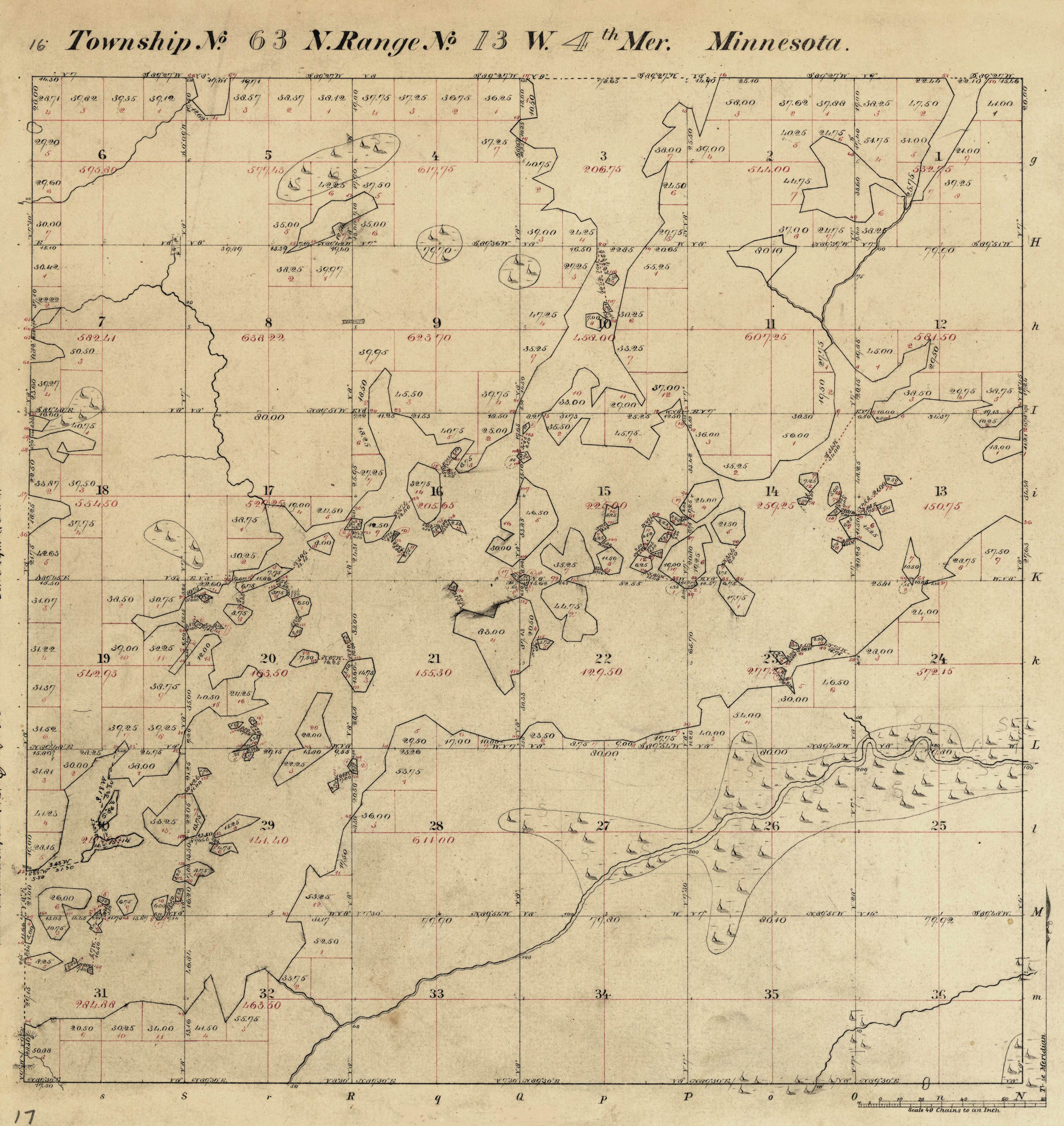
1881 Survey T63N R13W Burntside Lake

Sample Plat Map

"The original public land survey plats were created during the first government land survey of the state.  They serve as fundamental legal records for real estate, as an essential resource for surveyors, and as an analytical tool for the state’s physical geography prior to European settlement.  These plats are the official legal land records for Minnesota and all property titles and descriptions stem from them." The first survey in 1881 mapped the Burntside Lake area into square areas ("townships") measuring six miles east and west and north and south. Therefore, there are 36 square mile sections in each map. They are numbered from 1 to 36, beginning with the northeast corner and proceeding west and east alternately through the township.

Almost all of Burntside is contained in one map, enumerated in Minnesota as T63N, R13W (Township 63 North, Range 13 West). Three additional survey maps cover the remainder of the lake as follows: westernmost end: T63N, R14W, easternmost end: T63N, R12W, northernmost:T64N, R13W.

In 1902, and then from 1922 to 1925 additional surveys were conducted to include islands not previously established, or to correct island locations that were either nonexistent or incorrect. Most of these resurveys were in the west end of Burntside.

These following maps were downloaded as PDF files from the US Department of Interior Bureau of Land Management General Land Office Records. US Government Land Office from this web site: http://www.glorecords.blm.gov/ A wealth of information can be found there, including scans of the original Federal Land Patents for the transfer of properties from the Federal Government to the first private landowner. The State of Minnesota maintains a web site which provides access, in some cases easier access, to these survey maps and field notes made by the first surveyors: http://www.mngeo.state.mn.us/glo/. In the following table click on the highlighted map name to begin download. These PDF format land survey maps are several megabytes in size.

Public Land Survey Maps of Burntside Lake

Burntside LakeSurveyedArea of Lake MapMap Link
T63N R13W Original Survey
11/3/1881

Most of Burntside

View Map
2 Islands Section 30
5/12/1902
Islands
View Map
1 Island Section 21
5/13/1922
Islands
View Map
4 Islands Sections 13,20,29
5/25/1922
Islands
View Map
19 Islands Sections 20,21,29
3/29/1924
Islands
View Map
6 Islands Sections 17,20,32
3/29/1924
Islands
View Map
1 Island Section 22
12/17/1924
Islands
View Map
2 Islands Sections 14,20
3/17/1925
Islands
View Map
T64N R13W Original Survey
12/8/1890
North Arm
View Map
2 Islands Section 34,35
5/25/1922
Islands
View Map
T63N R12W Original Survey
3/31/1881
East End, Shagawa
View Map
T63N R14W Original Survey
12/8/1890
West End, Crab Lake
View Map

Each square mile section in a township consisted of 640 acres, which could be subdivided into progressively smaller rectangular parcels of land, for example of 320, 160, 80 or 40 acres. However, because of the lake, many Burntside parcels have an irregular boundary unlike the rectangular boundaries associated with "inland" acreage. The original survey enumerated these irregularly shaped "government lots", beginning in each section with lot 1and continuing until all such lots were accounted for. Some islands are contained in several sections, and have separate government lot numbers for portions within each section.

In the sample T63N R13W land survey shown above (click on the map to see a larger image) notice the centered section numbering begins with "1" in the upper right corner section, and continues right to left, then left to right and so on down the map until reaching section "36" in the lower right corner. Within each section, in red ink, the Government lot numbers are written on each irregularly shaped lot. Also within each section of the lake the amount of land acreage was calculated and recorded in red ink.

When Burntside property was made available by the United States for sale and homesteading in the 1880's, lakeshore property was first sold as whole government lots. Thereafter, owners could have their property surveyed and subdivided into parcels for sale to others. The results of these subdivision surveys were recorded and filed with St. Louis County as named plats. The earliest plat dates from 1921 when Van Vacton and Kate Harris, husband and wife created the Ke-wa-ne-na Beach Plat. It subdivided three North Arm government lots they owned into 44 approximately 100' lakeshores lots. The Sha-wa-nok Beach plat of 1927 offered property that now runs from Listening Point through Kaleva Bay and further east along the Burntside southern shoreline. Buyers sometimes purchased adjacent platted lots, as did Sigurd Olson when he obtained his Listening Point by combining several lots that still were unsold in the 1950's.

The scanned plat maps are from the St. Louis County plat search web site. The quality of the maps varies greatly. In the following table, click on the highlighted map name to begin download. These PDF format maps are generally less than a megabyte in size.

Plat Maps of Burntside Lake

Plat NameYear CreatedMap Link
Blueberry Island Addition
1990
View Map
Bevis Kenney Burntside Lots
1962
View Map
Bevis Kenney 1st Addition
1974
View Map
Burntside Outing Point
1927
View Map
Burntside Terrace
1924
View Map
Burntside View
1988
View Map
Davidson Park
1924
View Map
Deer Park
1964
View Map
Domich Plat
1964
View Map
Ke-wa-ne-na Beach
1921
View Map
Kewanena Condominiums
1987
View Map
Lindskog's Resort
1943
View Map
Lost Girl Island
1964
View Map
Mackies Lots
1968
View Map
Makwa Addition
2009
View Map
Mills-Carlson Plat
1958
View Map
Mollywood
1965
View Map
Moroni's Point
1960
View Map
Passi Lots
1941
View Map
Passi Plat No. 2
1944
View Map
Passi Plat No. 3
1951
View Map
Pete's Burntside Park
1931
View Map
Robert R. Reed Plat
1953
View Map
Registered Land Survey 47
2011
View Map
Stelter Plat
1963
View Map
Stelter Plat
1963
View Map
Sha-wa-nok Beach
1927
View Map
Valentine Island Addition
1990
View Map